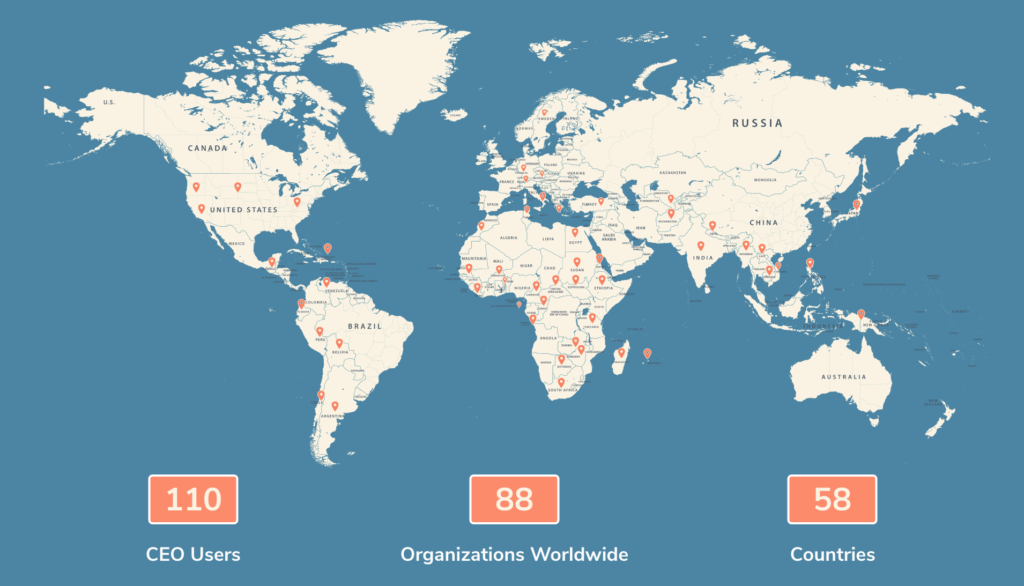
In order to better understand and serve our user base, the creators of Collect Earth Online (CEO) conducted a survey in March 2021. Input was collected from more than 110 CEO users working for NGOs and government agencies in 58 countries.
The survey revealed that CEO has attracted a global community of users who rely on the platform to drive high-impact work monitoring deforestation and other types of land use change. Among other critical uses, CEO is used to understand emission levels in the Peruvian Amazon, determine land cover types in Nepal, and assess the impacts of mining on vegetation in South Africa.
Results revealed a dedicated global user base. Respondents work for a variety of prominent organizations, including the Association for the Conservation of the Amazon Basin, NASA’s Jet Propulsion Laboratory, World Agroforestry, and World Resources Institute. CEO is also leveraged by government workers in Botswana, Nepal, the Democratic Republic of the Congo, and many others.
We compiled all feedback into an Intelligence Report. Read the report to learn more about: the demographics of your fellow CEO users, product usage and requests for improvements, and the real impact our users have on the ground (via customer use cases).
Through free, cloud-based software, CEO enables users to access satellite imagery to efficiently collect up-to-date data about their environment, monitor landscape changes over time, and use data to implement and enforce conservation policy. An intuitive, web-based interface enables multiple users—including students and members of the public—to contribute to image analysis and data collection.
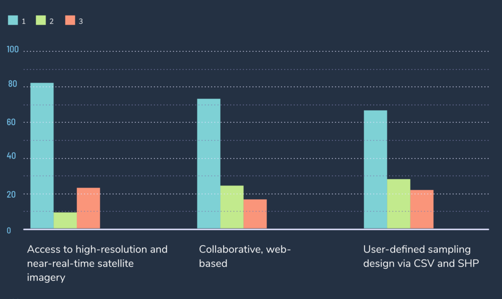
The availability of high-resolution, near-real-time satellite imagery is the CEO feature users value most, followed by the ability to conduct collaborative, web-based data collection, the survey showed.
Access to this imagery is courtesy of the government of Norway, which contracted with Planet and other groups to make this imagery available. The project is part of Norway’s International Climate & Forests Initiative (NICFI), an effort to stop deforestation and save the world’s tropical forests while offering sustainable pathways to economic development.
According to Hout Naborey, Chief of Office for Cambodia’s Ministry of Environment, access to NICFI’s high-resolution time series imagery “helps the interpreter make fast decisions.”
Peder Nelson of Oregon State University praised the ease of sampling and labeling, because it “saves time to have this in a browser-based environment.”
Users pointed to how easy it is to use the software, especially in comparison to traditional methods of land classification and monitoring, which are time-consuming and expensive.
The software is intuitive “even if the people are not heavily trained in remote sensing,” reported Trina Isorena of Protect Wildlife in the Philippines.
Users leverage CEO to understand what’s happening on the ground, develop compelling reports, and promote effective land use monitoring and conservation policy.
In Madagascar, the Peruvian Amazon, and the Commonwealth of Dominica, CEO has been used to support assessments of forest carbon related to REDD+ projects.
The government of South Africa uses the tool to detect large-scale land clearing for mining and renewable energy projects, while Cambodian officials use CEO to spot cleared forest lands.
In the rugged terrain of Nepal, where field studies are particularly difficult to undertake, CEO has proved invaluable in collecting data on land cover types.
Many survey respondents also reported using CEO to create reforestation and conservation plans, communicate project results to governments and NGOs, report compliance with climate change programs, and detect illegal activity causing forest loss or degradation.
The software is intuitive “even if the people are not heavily trained in remote sensing”
Trina Isorena of Protect Wildlife in the Philippines.

Many survey respondents offered valuable input for improvements and the addition of new features. Based on feedback, CEO developers are committed to implementing a series of updates over time.
Among other planned releases, here’s what’s on CEO’s roadmap:
The creators of CEO are continuously working to improve your experience on the platform. Your feedback is valuable and your input is welcome. Please feel free to reach out to us at support@collect.earth.
Ongoing funders FAO, NASA-USAID SERVIR, and SilvaCarbon
Technology partner NICFI, who makes high-resolution data available
Planet, who provides high-resolution imagery
The Google Earth Engine team who provide a platform for Earth science data and analysis
SIG-NAL, a non-profit the helps account for the value of natural assets
Spatial informatics Group, who provides development resources