The Collect Earth Online team has been hard at work solving bugs and adding new features in 2023. This includes updates to imagery and features in the Geo-Dash, a new rule type, and more. Check them out now!
🎨 Updates to imagery & Geo-Dash
We’ve made multiple improvements to the Institutional imagery and Geo-Dash. Some highlights include:
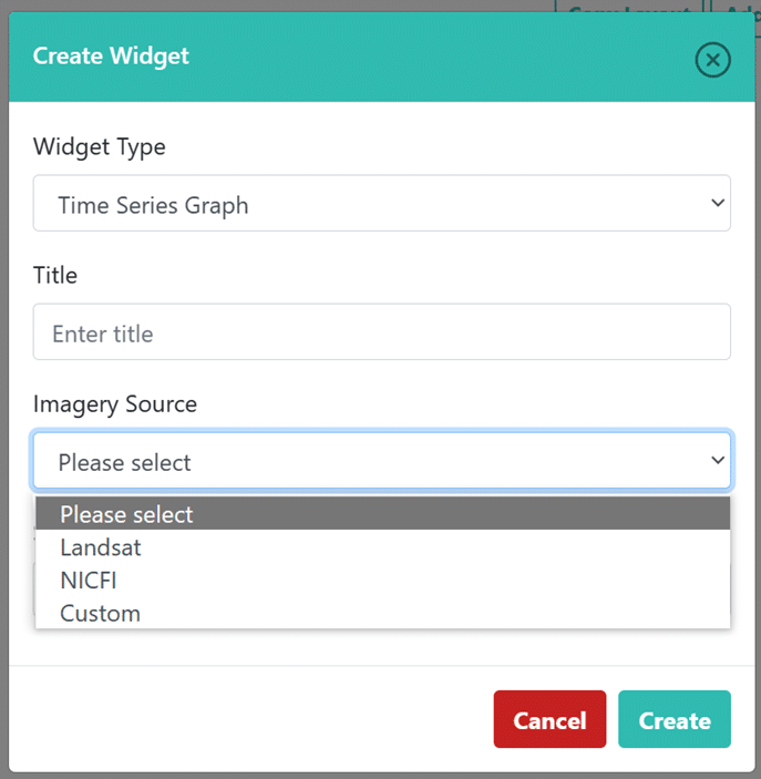
Added Planet NICFI imagery as an option to the Time Series Graph widget.
Added Planet NICFI imagery as an option to Preloaded Image Collections widget.
Modified the Preloaded Image Collections widget to allow selection by sensor type.
Modified the Preloaded Image Collections widget to collapse multiple Landsat missions into a single Landsat option.
For institutional imagery, added automatic list population for a custom image collection’s band names, instead of having to click the refresh button.
For both Institutional imagery and Geo-Dash, added min and max for each band in imagery for Landsat and Sentinel imagery. This allows for finer tuning.
Add date navigation buttons for Planet NICFI imagery.
Add date buttons for Planet NICFI on Geo-Dash widgets.
Planet NICFI data is now an option for the Time Series Graph widget.
These changes are in addition to the edit and delete functionality for Geo-Dash widgets that was added previously.
Perhaps the most important improvement is the ability to copy and edit existing widgets: copy, edit, and delete buttons are now found in the upper right-hand corner of each widget. Now you can easily create multiple widgets in a series—for example, one widget for each year you’re interested in or multiple widgets each displaying a different band or band combination.
Additional improvements include a simplified widget selection menu and the layout editor and Geo-Dash grid UI now match. In addition, users will now see two sliders (opacity and swipe) on the dual image widget at all times.
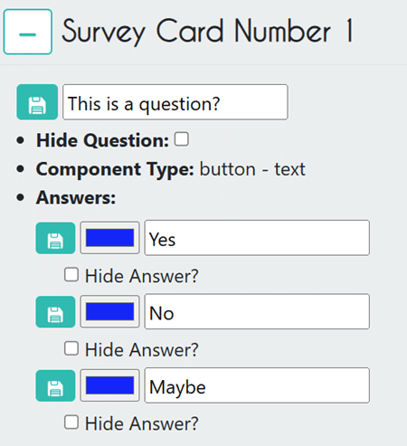
🔦 Hide questions and answers
Questions and answers can now be hidden using a simple check box in the Project Wizard. This feature can be used to improve data collection and facilitate downstream analysis.
For example, this functionality is useful when you want to use the same survey across multiple projects, but not every question is applicable to every project. This could be the case if you are collecting information on land cover globally, not all areas have the same type of forest so it does not make sense to include these options everywhere.
An example of the Hide Question and Hide Answer checkboxes. When these boxes are checked, the question or answer will be hidden during data collection.
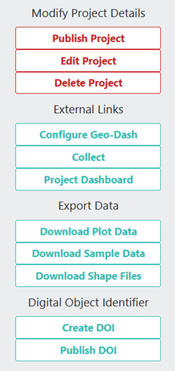
⚙ Download button for project shape files.
We have added a button to download the shape files (.shp) from your project. This will download the plot and sample polygons along with any data collected for them.
There is now a Download Shape Files button.
📋 Rules improvements
We’ve added two improvements to the Survey Rules.
Return to the previous correct answer if the new one doesn’t pass the rules check.
Add new rule type Multiple Incompatible Answers. This rule limits what answers can be chosen based on the answers for multiple other questions. For example, if you answer “landcover start = forest” and “change event = deforestation”, then “landcover end” CANNOT equal “forest”.
🌱Other improvements
Other new features include:
Add a checkbox on collection page for enabling a map grid.
KML exports are now hollow.
New DOI integration for publishing CEO datasets. A DOI enables unique and persistent identification and tracking of CEO datasets, enabling sharing of data collected in CEO.
🔧 Bug Fixes
When admin is reviewing interpretations, the application will only jump to the next plot if there are no more interpretations for that plot.
Fixed a bug where the Statistics GeoDash widget was not reporting elevation statistics for small plots.
Fixed a bug with reordering survey questions on newly created projections.
Fixed a bug with the sum rule.
Fixed a bug where certain nested questions would get duplicated when collecting.
Fixed an issue with preloaded Sentinel 2 composite only showing white using default visualization parameters.
Fixed a couple of issues with the UI displaying the correct number of plots assigned when using QA/QC functionality.
Fixed a bug for the Preloaded Image Collection widget, where composition images for the Sentinel-2 imagery source failed.
Fixed an issue where CEO would crash when deleting an answer that has a child question.
Fixed the issue where card orders were not being created for new projects, preventing the admin of the project from reordering the survey questions.
Fixed an issue where questions of type input-text and input-number were always required.
Fixed an issue with questions of type input-number in which if the answer were marked as required, it wouldn’t allow the user to input the number 0.
Fixed Statistics widget area calculation.
Fixed an issue in which the field for adding new users to an institution was case-sensitive.
When importing a project template from a different institution, user-plot assignments are now cleared.
Fixed issues with loading composite imagery for the Preloaded Image Collection Widget.
Fixed an issue with Time Series Graph Widget, which wouldn’t load the time series for custom assets. QA/QC assignments when using project template.
Fixed Geo-Dash imagery when using Sentinel-2.
Fixed Planet Daily imagery not loading.
Fixed a bug regarding the newest NICFI imagery, in which the images wouldn’t load.
Fixed an issue with band input treatment for Geo-Dash.
Fixed a bug with plot locks, where the server would sometimes incorrectly allow double interpretation of a plot.
Fixed plot sizes bug (they would get smaller the further away from the Equator).
Removed default date values for Image Collections.
Fixed Planet Daily integration.
Fixed language when uploading CSV and SHP files for plots.
Fixed language when assigning users to plots that were created using custom CSV or SHP files.
Text changes to more informative ones when error occurs.
When an admin is reviewing interpretations, the application will only jump to the next plot if there are no more interpretations for that plot.
Fixed SHP file exports for custom drawn samples.
Fixed behavior when the answer breaks a survey rule.
As always, you can get the most up-to-date information about new features and bugfixes on our GitHub page.
CEO would like to thank its ongoing funders FAO, NASA–USAID SERVIR, and SilvaCarbon, a US government program. Thanks also to CEO’s technology partners: Norway’s International Climate & Forests Initiative for funding open high-resolution data availability; Planet for providing high-resolution imagery; and the Google Earth Engine team for creating a platform for Earth science data and analysis.
Collect Earth Online is working constantly to improve the user experience, and your feedback is invaluable. If you have ideas to share, please write to support@collect.earth.