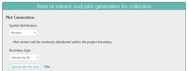
Collect Earth Online supports using polygons for delimiting Areas of Interest! You can find this option under “Boundary type” when adding information about your area of interest and plots in the Project Wizard.
Using a polygon as your Area of Interest (AOI) allows you to leverage the power of CEO’s random and gridded sampling designs! By using a shapefile, you won’t have to worry about using a third party program to generate a random stratified sample or a gridded sample inside your polygon.
To use your own polygon for your project’s AOI, start by making sure the polygon is saved as a shapefile (.shp). Next, use your favorite program to create a zip file with the requisite shapefile component pieces (.shp, .prj, etc.).
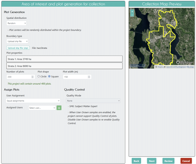
Then, simply choose “Upload shp file” in the Boundary type dropdown and upload your zipped folder by clicking on the “Upload shp file (zip)” button. Once you click open, you should see the File: text populate with your file name and your project boundary appear in the Collection Map Preview pane.

That’s it!
CEO will now load your shapefile and show you a preview in the Collection Map Preview pane. You will also see information about the size of your shapefile under Plot properties. If you have uploaded a shapefile with one polygon, there will be one strata listed. If you have uploaded a shapefile with more than one polygon, multiple strata will be listed. You can mouse over each strata in the list to highlight it in the Collection Map Preview pane.

Shapefiles with more than one polygon can be used for creating stratified sampling designs. Stay tuned for a blog post describing how to use this feature!
CEO would like to thank its ongoing funders FAO, NASA–USAID SERVIR, and SilvaCarbon, a US government program. Thanks also to CEO’s technology partners: Norway’s International Climate & Forests Initiative for funding open high-resolution data availability; Planet for providing high-resolution imagery; and the Google Earth Engine team for creating a platform for Earth science data and analysis.
Collect Earth Online is working constantly to improve the user experience, and your feedback is invaluable. If you have ideas to share, please write to support@collect.earth.
Thank you!